2025
DEP revised drawings; after Council members reviewed, the 3/18/35 letter was signed accepting the revisions. The next step is for DEP's surveyor to revise easement documents.
DEP is also moving ahead with Phase 1 and 2 on easements obtained so far.
2024
April: New maps have arrived; there were some issues of concern with revisions, so the Sponsor Agreement was not yet signed.
2023
No news on re-alignment, previously "next month or two" in November 2022; Rep Clint Owlett attended December Borough meeting to listen to resident complaints, will reach out to DEP, and will revisit in spring for a walking tour
Navarro & Wright scheduled to begin excavation on Hose Company in April; but in May, reported as "on hold until contract budget is confirmed." Rescheduled for July, "shovel test pits ... each will be 2 feet in diameter and a maximum of 3.3 feet deep, excavated manually with a shovel and the soils screened to recover any cultural remains (artifacts)." Confirmed only one excavation open at a time, and none left open at the end of a workday.
2022
(11/15/22) email from DEP: "We are getting close to finalizing the revised R/W drawings that avoids the FEMA buyout property. ... We are hoping to provide the R/W drawings in the next month or two."
Shane L. Erdman is the new DEP project coordinator for the Monroe Flood Project. Progress on the PREVIOUSLY approved R/W drawings was halted because part of the propossed levee crosses a FEMA buyout property. Appeals to FEMA to allow the flood project failed (as noted below, Jan/June 2020).
As of July 2022, Hilsher Cole has been working on revising the R/W drawings based on a new proposed alignment that avoids this property and we are awaiting finalized R/W drawings for review and approval. (7/22/22) "We will need the Borough to approve the new alignment prior to anymore progress on the project."
A list of open space land uses is available on the 3rd page under “CHAPTER 1 - OPEN SPACE USE QUESTIONS & ANSWERS” at: www.fema.gov/pdf/government/grant/resources/hbphase4.pdf. ("note that this pdf is dated October 1998 and may have been updated since but this was the most current list that I was able to find." (7/18/22)
(3/7/22)Bureau’s consultant plans to start work next week on properties with signed easements (easements signed in fall 2020)
2020
January - June: Further appeal of FEMA easement denial was unsuccessful; last adjustment to re-alignment was not feasible, another alteration is being considered. DEP will be developing draft Right of Way Plans for review and expect to hold a public meeting when plans are available (perhaps January 2021).
Phase 1B archeological work should continue, a work session is needed to determine best approach. (postponed several months due to covid quarantining.)
Chesapeake expressed interest in water withdrawal, DEP advised that heavy traffic would be damaging to the levee.
July - (Oct): Work session held, mapping and letters to landowners resumed. The DEP Project Coordinator left, no one yet hired to replace him, temporary contacts were provided.
2019
January - June: Borough was notified of FEMA's denial for an easement on the former buyout property on Willow St. , so DEP made adjustments to alignment of levee. Additional easements will be needed. (see letter) Due to difficulty of engineering around buyout property, DEP is exploring additional options. Second phase archeological exploration requirements should remain unaffected.
An outreach letter was sent to landowners in levee path in April, offering to meet individually to review maps and address questions/concerns. Questions from landowners were relayed to and responded to by DEP.
July - December: Easement papers for 1B archeological surveys have been received from DEP for review and signature; creating list and addresses of affected landowners; requested maps from DEP to indicate boring locations, printing map snippets before contacting affected landowners.
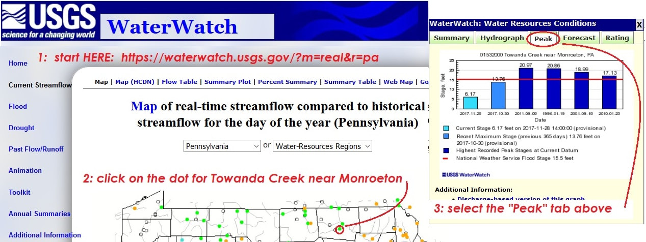
visit USGS WaterWatch.usgs.govfor real time AND historical streamflow information collected at Gage Station USGS 0153200 (Towanda Creek near Monroeton)

ALSO see USGS for webcam and more info from the Susquehanna River gage station, on the right bank at Bridge Street in Towanda, 1.8 mi upstream from Towanda Creek. (USGS 01531500 )
2018
January thru July: DEP geologist placed stakes for newly hired soil boring consultant; soil bore drilling completed on April 23rd. Continued gathering temporary archaeological easements; "Order to Proceed" issued to Navarro & Wright Consultant Engineers to begin archaeological survey.
August - December:August - December: Navarro & Wright conducted phase 1A of archaeological survey. (4 inch holes drilled by a one or two person crew with a hand auger and maybe a tarp; no heavy equipment or machinery, work for this phase was less invasive than the borings and in some cases the owners may not have been able to tell that the archaeological crew was there.) N&W survey report indicated a need for additional surveying. Next step will be phase 1B archeological survey. (shovel test pits and visual reconnaissance.)
DEP provided a "Solicitor Information CD" with Deed files, Easement Descriptions, Maps, Road Records, Railroad Records, and a list of questions for Solicitor review. (File names are not descriptive, no table of contents was provided. Borough Project Coordinator created a table to cross reference land owners and related parcel deeds, maps, etc.)

2017
Gathered temporary easements to allow soil bore drilling; and began gathering temporary easements for archaeological investigation . Met with DEP for a work session to get better understanding of the project phases. At end of project, a letter of map revision (LOMR) will be submitted to request a revision to the Flood Insurance Rate Map. (see fema.gov/letter-map-revision and fema.gov/conditional-letter-map-revision ); attended Monroe Hose Co meeting to provide updated maps and information, document concerns, and answer questions. Questions were relayed to DEP, and answers forwarded to Hose Co. (interesting link regarding stream flows: water.usgs.gov/edu/streamflow2.html )
An architectural historian recorded photographic notes in September; soil bores were marked, Geostructures Inc. began soil bore drilling in October, but were unable to complete their contract, drilling is discontinued until spring. DEP met with landowners across creek to discuss flowage easements.
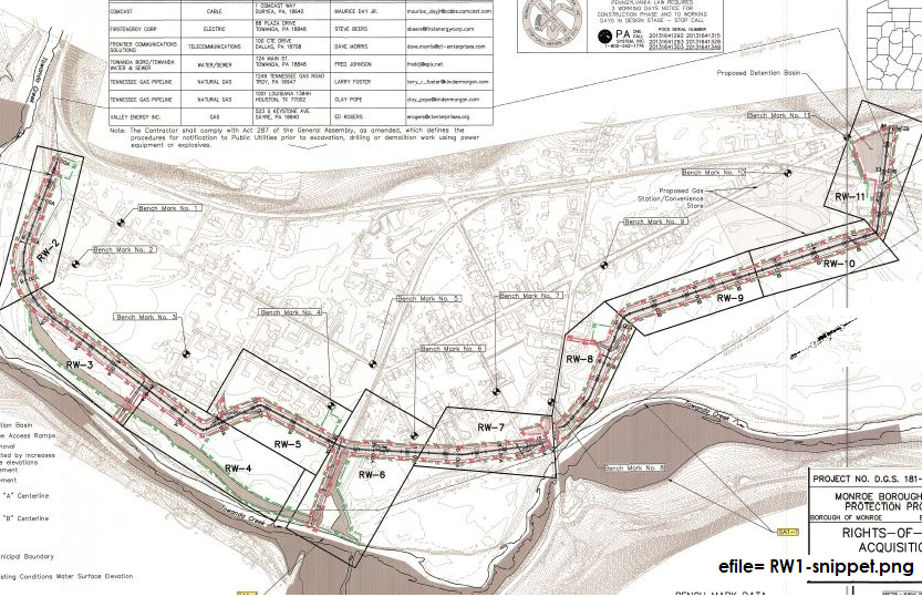
Map below shows PROPOSED, not final, levee location. (NOTE ABOUT ORIENTATION: north is NOT directly upward, it is to the RIGHT top corner.) Because a prior buyout property is situated within the proposed levee path, easement approval is needed from FEMA, as a "permitted open space" use. DEP has forwarded the necessary documents to PEMA so they may file the easement request.

2016
August: DEP provided maps and easement documents.
2015
July: Property boundary survey/mapping and easement documentation prep began (Larson Design Group)
2014
October: Passed Floodplain Ordinance #149
July: Borough approved sponsorship agreement for Project "Flood Protection Project", Proj No. DGS 181-26. (see Daily Review news article)
June: DEP presented powerpoint at public meeting
February: DEP completed PRELIMINARY Design and "sponsor adjustment schedule" (Borough responsibilities)
2012
April: excerpt from FLOOD INSURANCE STUDY NUMBER 42015CV000A, PRELIM, Federal Emergency Management Agency (full refers to analyses for the January 1980 FIS and the July 16, 1980 FIRM prepared by Gannett, Fleming, Corddry, and Carpenter, Inc., and for the September 17, 1992 study by GEO-Technical Services, Inc.,) 187 page document here
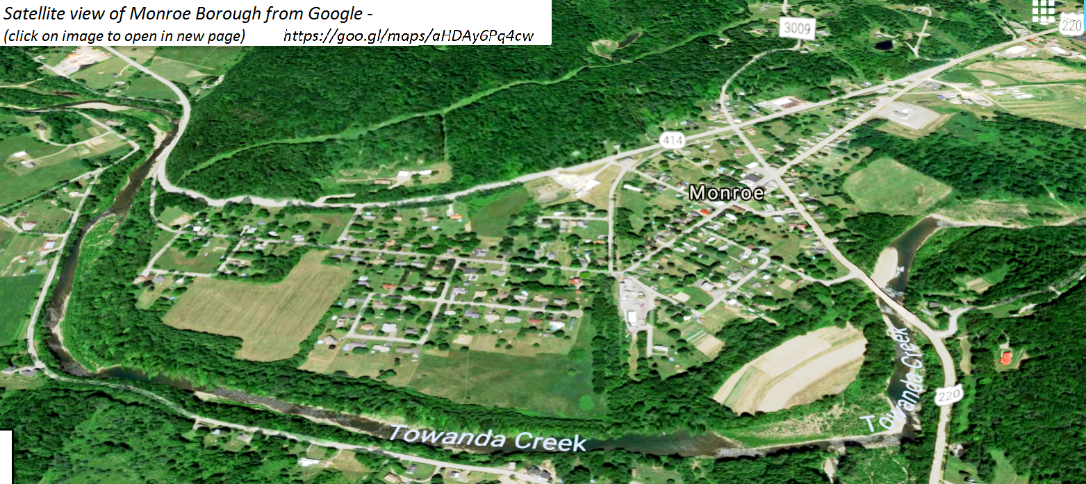
... At present, there are three levees within the Borough of Monroe. The first is located south of the abandoned railroad bed, the second is located north of the abandoned railroad bed, and the third is located north of the U.S. Route 220 (Bridge Street) bridge. The second levee is thought to be the remains of a bank of an older bed of Towanda Creek. The levees are relatively ineffective for flood control. Although the crest elevation of the system exceeds the 2-percent annual chance event at locations, the overall protection afforded is estimated to be the 10-percent annual chance, as determined by inspection of the crest elevations determined for this study (See Section 3.2). The 10-percent annual chance flood slightly overtops the levee just upstream of the abandoned railroad bed; however the majority of the flow from the 10-year flood is contained within the channel.
... Flood events of a magnitude which are expected to be equaled or exceeded once on the average during any 10-, 50-, 100-, or 500-year period (recurrence interval) have been selected as having special significance for floodplain management and for flood insurance rates. These events, commonly termed the 10-, 50-, 100-, and 500-year floods, have a 10-, 2-, 1-, and 0.2-percent chance, respectively, of being equaled or exceeded during any year. Although the recurrence interval represents the long term average period between floods of a specific magnitude, rare floods could occur at short intervals or even within the same year. The risk of experiencing a rare flood increases when periods greater than 1 year are considered. For example, the risk of having a flood which equals or exceeds the 1-percent annual chance flood (1-percent chance of annual exceedance) in any 50-year period is approximately 40 percent (4 in 10), and, for any 90-year period, the risk increases to approximately 60 percent (6 in 10)."
2009
DEP presented a project outline, timeline, and partner responsibilities at November 2nd Council meeting.
2006
DEP conducted feasibility study and recommended flood protection project; Borough passed resolution #1106 to sponsor DEP proposed project.
2000
Three homes damaged by the 1996 flood agreed to FEMA buyouts. (DailyReviewArticle-2000-femabuyout)
1997
Encroachment permit applications submitted by Monroe Township for earthen dikes along Schrader Creek. ( pabulletin.com )
1996
Borough requested DEP to conduct a feasibility study as a result of SEVERE flooding in 1946, 1972, 1975 and 1996 along Towanda Creek.
FURTHER BACK
(excerpts from minutes are being added below to give some historical perspective...)
1973
(from Feb 3, 1973 minutes, p411) Council passed a resolution requesting the US Soil Conservation service to implement a bank stabilization program on the Towanda Creek from Masontown Bridge to the LVRR bridge.
1971
(from Feb 1, 1971 minutes, p331) A letter was read into the minutes from the Dept of Forests & Waters giving the boro permission for the year 1971 to remove rock ledge and sediment from the channel of Towanda Creek downstream from Bridge Street in Monroe Boro. (acting sec’y Leo Dalpiaz)
1967
(from Aug 1967 minutes, p206) … Shaw reported he had Fred Walker of Forest and Water check over the creek where several spots were in very bad condition and should be taken care of before another flood came to the area. Secretary (Loomis) was instructed to write to Federal Flood Control in Harrisburg to have an authorized person check this condition.
1963
(from May 6 1963 minutes) Engineers from the Dept of Forests and Waters were here to look over the Creek and flooding problems. They are to follow up with a letter stating their recommendations.
1960
(from April 1960 minutes) The problem of flood control was brought up and Council decided to try again to obtain some State aid in coping with the threatening situation below the concrete bridge where the bank is gradually being washed away. (Frances Smith, Sec’y)